Antonovka
Rivne district, Rivne region
Sources:
- Jewish encyclopedia of Brockhaus & Efron
- The volost's and the most important settlements of European Russia. Edition of the Central Statistical Committee. The provinces of Little Russia and Southwest. St. Petersburg, 1885
- A.I. Kruglov, "Antonovka", [in:] I.A. Altman (ed.), Holokost na tieritorii SSSR, Moscow 2009
Antonovka (Antonivka, ukr. Антонівка, rus. Антоновка), sloboda of the Volyn province, Rivne district, Tuchyn volost - a Jewish agricultural settlement, founded in 1833 on its own land.
The first 27 families settled in the colony were released for 50 years from recruitment, and for 25 years from paying taxes.
In 1868, the Jewish population was 417 people, with 347 acres of land.
In 1885, there were 40 Jewish courts in the colony, 737 people lived.
A prayer house, 2 shops, and a tanner factory acted.
According to the census of 1897, in total there are 647 inhabitants in the village, of which 620 were Jews.
In 1921, there were 482 Jews in Antonovka (90,1%).
On July 3, 1941, the village was occupied by German troops. The new authorities forced all Jews to designate their homes and clothes by the stars of David; Over time, this symbol was replaced by yellow circles.
In the fall of 1941, the Germans created an open ghetto in Antonovka.
The destruction of the Jewish community occurred at the end of August 1942. During the action, employees of the SD, gendarmerie and Ukrainian police brought about 500 Jews from Antonivka ghetto to the Kostopil region, where they were killed.
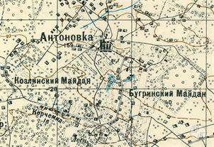
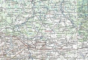
The village of Antonovka is present on the maps of 1941. After the Second World War, it probably ceased to exist, and in the future it is not mentioned anywhere.
Rivne region - list of settlements and location of objects
Antonovka, 2022
Antonovka, 2022

- Home
- Shtetls
- Vinnytsia region
- Volyn region
- Dnipro region
- Donetsk region
- Zhytomyr region
- Zakarpattia region
- Zaporizhzhia region
- Ivano-Frankivsk region
- Kyiv region
- Kropyvnytskyi region
- Luhansk region
- Lviv region
- Mykolayiv region
- Odessa region
- Poltava region
- Rivne region
- Sumy region
- Ternopil region
- Kharkiv region
- Kherson region
- Khmelnytskyi region
- Chernihiv region
- Chernivtsi region
- Cherkasy region
- Crimea
- Synagogues
- Cemeteries
- Objects & guides
- Old photos
- History
- Contact
Jewish towns of Ukraine
My shtetl
My shtetl
Donate
Jewish towns of Ukraine

